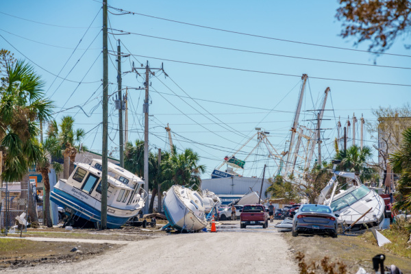
In the days leading up to Ian making landfall, weather forecasters were all warning of the Storm Surge. Before the cyclone even makes landfall, it will start pushing a dangerous flood of ocean water inland, hence the “surge.” The water can rush in quickly, carrying away people and property, washing out streets and other infrastructure, and flooding buildings. And as it turns out, they were right.
According to the National Hurricane Center (NHC), preliminary analysis of Hurricane Ian’s deadly storm surge suggests the Gulf of Mexico pushed as high as 15 feet above the normally dry ground on Fort Myers Beach, Florida, as it made landfall. That’s the peak estimate reported by a team of experts with the National Weather Service and other agencies who searched flooded homes and structures in the devastated area for high water marks this week.
The 10-15 feet peak high water levels at Fort Myers Beach puts Ian among some of the higher storm surges in history in the Atlantic basin but well below peak water levels reported in some of the most legendary storms on the northern Gulf Coast. “Pictures don’t do the destruction justice,” tweeted Jeffry Evans, meteorologist-in-charge of the National Weather Service field office in Houston, also a member of the survey team. “Complete and deadly inundation of the island.”
As Business Insider reports, this is how a storm surge happens and why it’s so dangerous.
Hurricanes stir up ocean water, then push it onto land
Hurricanes are large low-pressure systems that create a cyclonic wind effect. Those winds force ocean water to spin down into the water column, creating vertical circulation in the ocean below. Once the hurricane reaches shallow coastal waters, the ocean bottom interrupts this cycling. Unable to go down, the water pushes out onto land.
These water levels can rise rapidly — a few feet in just one minute, according to the Coastal Emergency Risks Assessment.This generally happens where the hurricane’s winds blow toward the shore, pushing the surge of water in that direction. The highest storm surge tends to occur with the hurricane’s strongest winds. A storm surge can also arrive before a hurricane’s winds do, closing off roads and cutting evacuations short.
Storm surge can be deadlier than hurricane winds
While hurricane-force winds can rip roofs off of homes and take down trees and power lines, the surge of ocean water rushing inland often causes more damage. It doesn’t take much, either: According to the NHC, just 6 inches of fast-moving water can knock over an adult, and it only takes 2 feet to carry away an SUV.
Hurricane Katrina’s 20-foot storm surge in New Orleans breached the city’s levees 15 years ago. Elsewhere, Katrina’s storm surge reached 30 feet. More than 1,800 people died in that storm and the ensuing floods, which also caused $108 billion in damage.Storm surge often arrives before a hurricane’s winds, closing off roads, cutting evacuation routes, and leaving people stranded in flood zones. That’s part of what makes the phenomenon so dangerous. Surges can also continue after the storm’s center passes, preventing emergency responders from reaching flooded areas.
The Saffir-Simpson scale, which ranks hurricanes in categories 1 through 5 based on wind speeds, does not account for storm surge, so even cyclones weaker than Katrina or Laura can produce huge walls of ocean water.
If a surge coincides with high tides, it gets an extra boost. That’s what happened when Hurricane Sandy flooded New York City in 2012. Heavy rainfall can also compound the effects of a storm surge, dumping more water on top of the ocean flood. That was especially true during Hurricane Florence, which drenched the Carolinas in 2018, and Hurricane Harvey, which dumped more than 60 inches of rain on parts of Texas in 2017 and killed at least 68 people.
Warming, rising oceans can make storm surges more devastating
Larger, stronger, faster cyclones generally produce higher storm surge. And as Earth’s oceans and air get warmer, tropical storms overall are getting stronger, wetter, and slower.
Rising sea levels can make storm surges even more devastating by giving them a higher starting point and allowing them to reach further inland.
“Our confidence continues to grow that storms have become stronger, and it is linked to climate change, and they will continue to get stronger as the world continues to warm,” James Kossin, an atmospheric scientist at NOAA who studies how climate change affects tropical cyclones, told the Washington Post in 2020.
—
Photo Credit: Felix Mizioznikov / Shutterstock.com
