A swarm of tornadoes tore across parts of central North Dakota and South Dakota Sunday afternoon, leaving some damage as flooding rainfall swamped Bismarck during a bizarre September limited outbreak of severe weather in the Northern Plains.
More tornadoes touched down in North Dakota on Sunday than the state had seen in any September over the past three decades, combined.
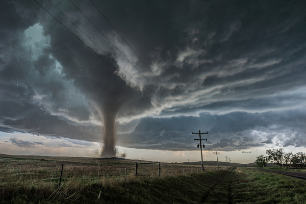
20 Tornado Reports in Just Over Six Hours
As AccuWeather reports, the outbreak began near Mobridge, South Dakota, where storms flipped an SUV towing a trailer and knocked down power lines. From there, the system tracked north into North Dakota, passing east of Bismarck and Minot. Luckily, no injuries were repoted, according to Walworth County Emergency Management.
As The Weather Channel reports, tornadoes then tore through parts of Emmons, Burleigh, Sheridan, McLean and McHenry counties in North Dakota Sunday afternoon and evening. Some of these tornadoes were large with multiple vortices, as witnessed by several storm chasers.
In just over six hours, a total of 20 tornado reports were received by NOAA’s Storm Prediction Center in the Dakotas, with 18 in North Dakota. Since 1995, only 15 tornadoes had been reported in the month of September in the state, which typically has the most tornadoes in June.
Flooding Rain Caused Even More Problems for the Area
While severe thunderstorms and tornadoes remained east of the city, flooding rain hammered North Dakota’s capital city, Bismarck, on Sunday. Flooding also closed streets and stranded vehicles Sunday in Jamestown, North Dakota, about halfway between Bismarck and Fargo.
Bismarck Municipal Airport picked up almost 2 inches of rain in less than an hour, swamping streets and underpasses and stranding vehicles in the city, according to The Weather Channel. One video posted on social media showed water seeping into at least one downtown business.
The 2.44-inch storm total was the city’s wettest September day in 31 years, and more than the entire September average of 1.72 inches.
What Causes Tornadoes?
According to the National Weather Service, the key atmospheric ingredients that lead to tornado potential are instability – warm moist air near the ground, with cooler dry air aloft and wind shear – a change in wind speed and/or direction with height. An unstable airmass promotes the development of strong updrafts, while wind shear will further increase the strength of the updraft, and promotes the rotation from which tornadoes are produced.
The most active months for North Dakota tornadoes are typically in June and July, according to the NOAA’s Storm Prediction Center. “This was a unique environment where the instability didn’t really favor much in the way of hail or strong winds, but the low-level shear right near the low pressure system and warm front lifting through N.D. was intense,” said NWS-Bismarck science and operations officer Chauncy Schultz.
Nationally, there have been only 20 other tornadoes reported this entire month.
Significant Outbreak Sets New Records
As of Monday night, the National Weather Service (NWS) had confirmed 5 tornadoes from the outbreak, including 2 EF2s and 2 EF1 twisters, although the confirmed tornado reports number may change as the National Weather Service surveys additional tornado damage. Regardless, North Dakota averages only 22 tornadoes over the course of an entire year, so this is a significant outbreak for the state.
The NWS issued 25 tornado warnings for the storms. Only 27 September tornadoes had previously been recorded in North Dakota since 1950, according to NOAA’s database. Since 1995, only seven tornado warnings had ever been issued during the month of September.
The previous record for the most tornadoes in North Dakota is one day is 24, set on June 11, 1976. The last damaging North Dakota September tornado happened eight years ago — Sept. 19, 2017 — near Litchville in Barnes County.
To add to the surreal weather event, as the thunderstorms continued into the evening, the greenish tint of the northern lights coincided with flashes of lightning over the state on Sunday night.
—
Photo Credit: Cammie Czuchnicki / Shutterstock.com