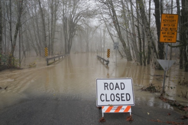
Back-to-back atmospheric rivers have doused the Pacific Northwest as of late, resulting in flash flooding, damaging mudslides and swollen rivers. Some locations have already picked up over a months’ worth of rainfall within just a few days amid the active pattern.
Although the region caught a brief break from the intense storminess over the weekend, conditions won’t stay quiet for long. Another round of storms, including a specific type of atmospheric river known as the “Pineapple Express,” is set to arrive this week.
What’s a Pineapple Express?
This conveyor belt of moisture originates near the Hawaiian Islands, which is how it earns its name, and will transport a relatively warm, humid stream of air toward the Northwest U.S. and will be capable of producing intense and long-lasting rainfall. Depending on how long the pattern persists, these events can deliver exceptionally high rainfall totals. This particular event will commence on Monday and last through Wednesday morning, although there will be additional chances for rain and high-elevation snow later this week too.
Repeat rounds of rainfall will be funneled into western Washington and Oregon as well as Northwest California into Wednesday. In the typically colder spots, rain can mix with snow at times, particularly during the overnight hours. “Snow levels will begin to fall Monday night, especially in Washington. This can lead to accumulating snow as low as 4,000 feet, which includes Stevens Pass,” noted AccuWeather Meteorologist Alex Duffus.
From Tuesday night into Wednesday morning, a cooler push of air will increase the chance for widespread accumulating snow across the region.
Another deluge of rainfall to heighten mudslide risk
Steady precipitation will target upslope areas and higher terrain, particularly the Olympic Mountains, the Coastal Range and the Cascades, where 2–4 inches of rain is expected. Terrain enhancement may boost totals even further on windward-facing slopes, where amounts upwards of 4 inches are possible, with an AccuWeather Local StormMax™ of 12 inches.
Additional rainfall moving into areas that already received several inches over the past week will only worsen ongoing issues. The risk of more mudslides will increase, especially as runoff intensifies through midweek. “Several inches of additional rain this week, on top of what fell last week, can lead to a renewed risk of major flooding, including on some rivers that crested in record territory,” added Duffus.
Duffus added that even after the rain winds down around midweek, rivers will take a few days to crest. Residents and businesses in flood-prone areas should not let their guard down during the lull in the rain this weekend and may need to make preparations for additional, potentially major flooding through the week.
Blustery winds on the way midweek
Into Wednesday and Wednesday evening, intense winds will pick up across the Northwest states. Once a storm ushers onshore late Tuesday, winds at the coast will peak around 50 mph, forecasters warn. Farther inland, even blustier conditions will arise throughout the northern Rocky Mountains and surrounding terrain throughout Washington, Oregon, Idaho, Montana and Wyoming.
While the windiest conditions will center around the northern Rockies, the surrounding states from northern Nevada, Utah, Colorado and into the Front Range will also face the risk for damaging gusts around midweek.
Travel can be impacted with gusts upwards of 60 mph possible across interstates 25, 90 and 94, with an elevated crosswind hazard for high-profile vehicles. The AccuWeather Local StormMax™ for wind is 90 mph from Wednesday to Wednesday night.
Additional storms expected late week
There will only be a minor break following the early week storm activity before yet another feature crosses into the Pacific Northwest packing additional rain and snow hazards.
Later this week, parts of Oregon can face the highest risk for additional flooding problems with notable rain expected from Portland to Medford. Travel impacts are anticipated along portions of Interstate 5 as a result, with inundated roadways, downed trees and landslides all on the list of hazards possible.
Given the preceding wet conditions and the substantial amount of additional rain expected throughout the week, there is a possibility for renewed flooding impacts to be catastrophic in nature in some locations.
—
Photo Credit: Terrence J Allison / Shutterstock.com