Two wildfires burning in the western United States — including one that has become a “megafire” on the North Rim of the Grand Canyon — are so hot that they are spurring the formation of “fire clouds” that can create their own erratic weather systems.
As AP News reports, since igniting on July 4, the Dragon Bravo Fire in Arizona that destroyed the Grand Canyon Lodge, has burned 116,592 acres with 1,214 fire personnel assigned to contain it as of August 3, making it the largest wildfire burning in the United States one of the largest wildfires in Arizona’s history.
Containment of the wildfire rose slightly to 12%, up one percentage point from the previous day and aided by a brief rise in humidity, according to the Southwest Complex Incident Management Team.
The Monroe County Fire, burning since July 3 near Richfield, Utah, is the largest in the state and has now scorched more than 61,000 acres with only 4% containment, as of Sunday. Evacuation orders were issued last week for several towns in the fire’s path, and scorched power poles caused electricity to be shut off in other nearby communities in south-central Utah.
Fire crews, working around the clock, say challenging terrain, persistent wind and dry fuel have made this fire especially difficult to fight. A state of emergency declaration by Governor Spencer Cox (R-Utah) remains in effect and the cause of the fire is under investigation. While some evacuation orders have been lifted, others remain in place.
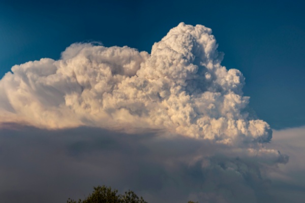
‘Fire Clouds’ present Unique Challenges for Firefighters
Towering convection clouds known as pyrocumulus clouds have been spotted over Arizona’s blaze for seven consecutive days, fueling the fire with dry, powerful winds, fire information officer Lisa Jennings said. They form when air over the fire becomes superheated and rises in a large smoke column. The giant billowing clouds can be seen for hundreds of miles and can resemble an anvil.
Their more treacherous big brother, a fire-fueled thunderstorm known as the pyrocumulonimbus cloud, sent rapid winds shooting in all directions this week as a smoke column formed from the Utah fire then collapsed on itself, fire team information officer Jess Clark said.
“If they get high enough, they can also create downdrafts, and that’s something we really watch out for because that can quickly spread the fire and can be very dangerous for firefighters who are doing their work on the ground,” Jennings said.
Multiple fire crews in Utah were forced to retreat last week as the unpredictable climate created by the clouds threatened their safety, officials said. Fire crews in both Utah and Arizona had better control of the blazes, but containment has been slipping as the fires grow rapidly.
The same type of cloud, which the National Aeronautics and Space Administration (NASA) has dubbed the “fire-breathing dragon of clouds,” recently formed a fire tornado that tore through an eastern Utah neighborhood with wind speeds estimated at 122 miles (196 kilometers) per hour.
“Think of the fire as kind of like a hot-air balloon, so it adds buoyancy and things rise as a result,” said Derek Mallia, an atmospheric scientist at the University of Utah who studies pyrocumulonimbus clouds and tracks fires in Utah and Arizona. “You get this towering thunderstorm over the fire, and just like any other thunderstorm it gets really windy underneath it. Because it’s the West, these thunderstorms tend to be very dry.”
These clouds, he said, may appear more frequently as climate change causes a longer fire season, drought conditions and extreme weather events.
—
Photo Credit: Thomas Morris / Shutterstock.com