As many as a half a dozen storms are expected to roll onshore in the northwestern United States through next week, bringing periods of drenching rain to lower elevations and accumulating snow to the higher terrain. One of the more potent storms, forecast to arrive Thursday night into Friday, will tap into a firehose of moisture known as an atmospheric river, AccuWeather meteorologists warn.
Meteorologists say that while the rainfall could give some relief to long-term drought conditions, the rains of this severity will likely cause major travel disruptions. Additionally, quick rises on some of the small streams and short-run rivers in the region will become more likely with each successive storm. “There will be an increasing risk of mudslides and other debris flows in recent wildfire burn scar locations,” AccuWeather Meteorologist Kia Kerkow said.
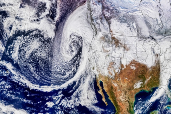
As of midweek, satellite images showed a long plume of moisture extending from Japan and the Philippines to just off the coast of the northwest coast of the United States. This long conveyor belt of moisture, or atmospheric river, is expected to reach the U.S. coast before the end of the week as a storm moves ashore. Additional storms may follow, bringing repeated rounds of an atmospheric river activity through next week.
What is an Atmospheric River, and How Does it Form?
When you think of the atmosphere, you probably think of gases like nitrogen and oxygen—the air we breathe. But did you know the atmosphere can hold an entire river of water too? According to the National Oceanic and Atmospheric Administration (NOAA), Atmospheric Rivers are long, flowing regions of the atmosphere that carry water vapor through the sky. They are about 250 to 375 miles wide and can be more than 1,000 miles long. Rivers on land generally flow downhill; atmospheric rivers flow in the direction of moving air created by weather systems.
In general, they pick up water vapor from the warm, moist air of tropical regions and they drop the water over land in cooler regions as rain or snow. So, much like a river is water moving over land, an atmospheric river is a stream of water vapor moving in the sky.
Atmospheric rivers typically form over tropical regions. Warm temperatures there cause ocean water to evaporate and rise into the atmosphere. Strong winds help to carry the water vapor through the atmosphere. As atmospheric rivers move over land, the water vapor rises up farther into the atmosphere. It then cools into water droplets, which fall as precipitation. One well-known atmospheric river called the “Pineapple Express” picks up warm, moist air near Hawaii. When the Pineapple Express hits land in the Western United States and Canada, it can cause heavy rain and snow. In California, it can cause up to 5 inches of rain in a day.
How Common are Atmospheric River Events?
If you hear your local meteorologist talking about an atmospheric river, you can probably expect lots of rain or snow in the forecast. Atmospheric rivers are fairly common in winter in the Western United States. In fact, just a few atmospheric river events each year cause up to half of the annual precipitation on the West Coast. These dumps of rain and snow from atmospheric rivers are an important source of fresh water for the West Coast. However, sometimes this heavy precipitation—which can park over a region for several days—can lead to flooding, mudslides and other disasters.
Scientists monitor atmospheric rivers to plan for emergencies and water supply issues. NOAA’s GOES West weather satellite captures images and information, such as the amount and location of moisture in the atmosphere on the West Coast, as often as every 5 minutes. This is important for weather forecasters to make accurate forecasts of heavy rain and flash flooding. Accurate forecasting of these events can help people prepare and stay safe.
—
Photo Credit: BEST-BACKGROUNDS / Shutterstock.com