On the heels of a week that saw deadly tornadoes, thunderstorms, flooding and large hail, the midwest is set to see more of the same, as severe weather is expected to sweep across much of the midwest in the coming days.
According to the National Weather Service (NWS), a “very active Spring weather pattern” is forecasted for the central U.S. into early next week, beginning with strong winds and large hail threatening Kansas and Oklahoma. “A complex weather scenario will unfold today into tonight, with higher confidence in the threat for very large hail and tornadoes tonight across Kansas,” the NWS Storm Prediction Center posted to X on Sunday. “A conditional severe threat will extend southward into Oklahoma.”
NOAA’s Storm Prediction Center (SPC) has issued a Level 3 out of 5 risk of severe storm threat across parts of the Midwest and Mississippi Valley, including eight states such as Missouri, Wisconsin and Iowa. Forecasters say St. Louis, MO, could see some of the greatest impacts.
Flash floods threaten Midwest
Excessive rainfall could also lead to flash floods. Sunday advisories are in effect for eastern Kansas, western Missouri, southern Iowa and Nebraska. Come Monday, April 27, eastern Iowa and northern Illinois – including urban areas around Chicago – face a “slight risk for excessive rainfall,” the NWS reported.
As The Weather Channel reports, this stormy pattern will bring more periods of rain to parts of the western Great Lakes either still experiencing flooding or where ground is already saturated from the deluges both last week and earlier this spring. While the NWS didn’t anticipate the magnitude of rainfall seen last week, over an inch of additional rain is a good bet in much of the Midwest through Monday. That could lead to at least isolated additional flash flooding and could slow the fall of rivers still in flood.
AccuWeather Senior Meteorologist Dan Pydynowski said that Monday’s risk zone will extend nearly 1,000 miles, from Mississippi to Wisconsin, with the “greatest threat for damaging storms” hovering above the St. Louis region.
Locally flooding rain is also possible through Monday from parts of Missouri and Kansas into Arkansas and the mid-South region, even though some of these areas are in extreme drought. Beware of flooded roads, especially at night when you may not recognize them as fast. Never attempt to drive through a flooded road. “Don’t drown, turn around,” instead.
Tornado Advisory Extended
Sunday’s storm system is expected to move eastward on Monday, April 27, into Iowa, Missouri, Illinois and other areas within the Middle-Mississippi Valley, bringing with it the potential for “large hail, strong to severe winds, and strong tornadoes,” according to the NWS.
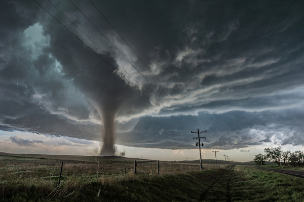
The threat of supercell thunderstorms was in play in the Central and Southern Plains over the weekend, especially in parts of Kansas, Nebraska and Missouri. With enough warm, humid air and strong wind shear in place, these supercells could spawn strong tornadoes, in addition to very large hail and damaging wind gusts. Cities like Kansas City and Oklahoma City need to be on alert.
“A few long-track, particularly dangerous, tornadoes are possible,” The Weather Channel noted. It added in a separate post for April 27, “Tornadoes could reach up to EF3 or even higher in intensity, and the threat lasts into the overnight hours, so anyone facing the severe threat should have a reliable way to get alerts when they go to bed.”
On Monday, this higher severe threat could spread to the Mississippi Valley and lower Ohio Valley. Another day of supercells could spawn strong tornadoes for parts of Iowa, Missouri and Illinois. A few long-track, particularly dangerous, tornadoes are possible. Places like St. Louis, Kansas City, Little Rock, Nashville, Indianapolis, Chicago and Des Moines should all be on alert.
Oklahoma is still recovering after a series of tornadoes left 10 people injured and multiple homes damaged across Braman and Enid, home to Vance Air Force Base, on Thursday, April 23. In a post on X at the time, Oklahoma Gov. Kevin Stitt urged residents in the affected area to “stay weather aware, follow local warnings, and take shelter immediately when directed.”
—
Photo Credit: Cammie Czuchnicki / Shutterstock.com
