As the calendar turns from 2025 to 2026, gone will be the record warmth in the Central and Southern states, as well as the deluge of rain that soaked California through Christmas week. The snow and cold that have plagued parts of the Northern and Eastern states, however, could still present issues for those with travel or outdoor plans.
“A majority of the nation can expect relatively quiet conditions for New Year’s Eve festivities,” AccuWeather Meteorologist Brandon Buckingham said. “However, a zone to watch for snowy conditions and the potential for slick travel will likely span from the Upper Midwest to the Great Lakes and Northeast.”
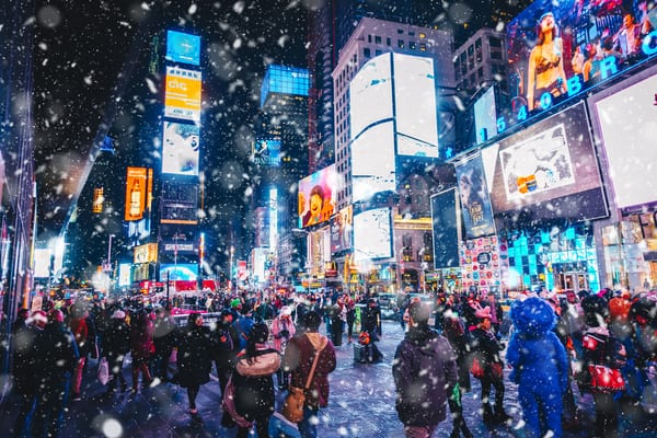
More Slippery Snow from Midwest to Northeast and NYC for the Ball Drop on NYE
As AccuWeather reports, a part of the country that has been no stranger to snow and cold so far this season will get more of it to close out 2025 on Wednesday. “A storm sliding in from Canada between New Year’s Eve and New Year’s Day is expected to usher in accumulating snow and a reinforcing shot of cold air across the Midwest, Great Lakes and Northeast,” said Buckingham.
A few inches of snow can accumulate from this storm. Where exactly that falls depends on the track and speed of the storm, but it appears the Great Lakes region to New England could end up being ground zero, with the snow potentially lasting into New Year’s Day.
Surging Arctic air will keep temperatures in the teens and 20s for most of the Northern states. The early call in Times Square, New York, for temperatures as the ball drops is to be around the freezing mark.
For those traveling in the region, delays due to slippery roads and runways and lower visibility in heavier snow are possible.
After a Brief Sunny and Dry Period, More Rain for New Year’s in the West
A barrage of atmospheric rivers along the West Coast has resulted in a soggy (and in the higher elevations, snowy) month from California to Oregon and Washington. Following several days of dry, sunny and windy conditions, a new storm packing rain and travel delays will roll into California and the west coast midweek, just in time to cause problems for New Year’s Eve revelers and Rose Parade watchers on New Year’s Day.
Showers will overspread much of Southern and Central California during the afternoon and early nighttime hours on New Year’s Eve, spreading to Northern California, Las Vegas and Reno, Nevada, and Phoenix late Wednesday night and Thursday.
Despite the subtropical origin of the storm’s moisture, rainfall is not expected to be excessive in general. There will still be some pockets where the rain is heavy enough to renew the risk of mudslides and flash flooding, such as along the south- and west-facing slopes of the Transverse Range in Southern California. Fortunately, such heavy rain will not be widespread, nor will the related problems.
Most of the streams and rivers should be able to handle the rain without significant flooding. There can be the usual ponding along some streets and highways, where drainage is poor. AccuWeather meteorologists are also monitoring the potential for an offshore wind event in Southern California in the final days of the year.
“Conditions will be monitored for a possible Santa Ana wind event across Southern California,” said Buckingham. “Fortunately, due to all the recent rain, the risk for wildfires is expected to be minimal despite the chance for windy conditions.”
People heading to and participating in the annual parade in Pasadena, California, on New Year’s Day may want to wear waterproof shoes, a warm jacket and a plastic rain poncho. Temperatures will recover a bit in the afternoon for the football game, but it is bound to shower at least once or twice and could rain a lot more often than that.
Rest of the Nation Should be A-OK for New Year’s
Outside of the chance of snow in the Great Lakes and Northeast, a few showers in the Northwest and windy conditions in parts of Southern California, AccuWeather reports that New Year’s celebrations should go off without a hitch weatherwise across the rest of the nation.
Sprawling areas of high pressure, both over the Rockies and Southeast, will supply plenty of dry weather. Though they will not be to the level they were around Christmas, temperatures for millions will be quite a bit above the historical average, especially across the Rockies and Plains.
While the dry, snow-free weather will not be welcome by ski resorts in the West, it will make for smooth traveling by road and air. The chill in parts of the Midwest and Northeast will continue beyond the New Year’s holiday into at least the first full week of January, as new rounds of cold arrive from Canada in the wake of multiple cold fronts.
For those traveling over the balance of the nation, sunglasses will be handy by day. The record warmth from the southern part of the Plains to the Southeast will be long gone, but it should be far from cold by Wednesday and Thursday from Texas to Kansas, Arkansas and Louisiana.
Cool air will linger in the Southeast, particularly in Florida, compared to historical averages. Still, many people from the northern states heading to the theme parks in central Florida will probably not mind highs in the upper 50s to the mid-60sF.
—
Photo Credit: Clari Massimilliano / Shutterstock.com
