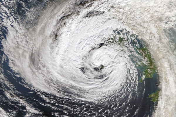
Hurricane Humberto continues to churn in the western Atlantic as a major Category 4 storm, while Tropical Depression Nine has strengthened into Tropical Storm Imelda, threatening the Bahamas and potentially parts of the Southeastern U.S.
As NBC News reports, the National Hurricane Center reported at 11 a.m. Sunday that Humberto was about 535 miles south of Bermuda with maximum sustained winds of at least 150 mph. The storm is expected to remain a powerful major hurricane, passing west of Bermuda by Tuesday evening. Humberto strengthened into a Category 5 Saturday night.
Even far from land, Humberto is already generating dangerous swells. The hurricane is expected to send life-threatening surf and rip currents toward Bermuda, the northern Leeward Islands, Puerto Rico, the Virgin Islands and the U.S. East Coast beginning Monday.
Tropical Storm Imelda has formed, Expected to Become a Hurricane
Tropical Storm Imelda was located about 95 miles west-northwest of the central Bahamas Sunday afternoon, with 40 mph maximum sustained winds. The storm is moving 7 mph and is expected to cross the central and northwestern Bahamas Sunday evening before turning east-northeastward, moving away from the U.S. later in the week. Forecasters expect Imelda to become a hurricane by late Monday or Tuesday.
Authorities have issued tropical storm warnings for much of central and northwestern Bahamas, including Cat Island, Exuma, Long Island, Rum Cay, San Salvador, Eleuthera, New Providence, the Abacos, Berry Islands, Andros and Grand Bahama. A tropical storm watch is in effect for Florida’s east cost from roughly Palm Beach to Flagler Beach. Both storms are expected to produce heavy rainfall, life-threatening surf, and dangerous rip currents.
Imelda could bring 6 to 12 inches of rain to the northwest Bahamas through Tuesday, while the Carolinas may see 2 to 4 inches of rain. Humberto’s swells are already affecting the northern Leeward Islands, the Virgin Islands, Puerto Rico and Bermuda.
In South Carolina, Gov. Henry McMaster issued an emergency declaration, state emergency officials said swift-water rescue crews have been activated, and the South Carolina National Guard said 150 troops were assigned to help with the state’s storm response. “The time to prepare is now,” McMaster said at a news conference Saturday.
The Fujiwhara Effect
When two tropical systems move within several hundred miles of each other, their circulations can begin to interact in a rare but fascinating phenomenon known as the Fujiwhara effect.
While both systems share the same ocean, they aren’t equals. Humberto is a much stronger and larger hurricane with a broad circulation and stronger winds compared to the weaker, more loosely organized Imelda.
In this setup, the stronger storm typically dictates the motion of the weaker one. And this case… it very likely will. In fact, Humberto could keep nothing more than scattered showers and storms from Imelda from hitting the southeast coast. This means that Humberto could actually prevent Imelda from doing more damage to the coastline.
As powerful Humberto spins, it can exert a pull on Imelda, almost as if the storms are connected by a string. Instead of Imelda freely moving north into the coast of the southeast, Humberto’s circulation disrupts that path, altering its trajectory, and tugging it to the east along with it.
Fewer major storms than average
The back-to-back action, not to mention Hurricane Gabrielle, which spun over the central subtropical Atlantic earlier in the week, are enlivening an otherwise sleepy 2025 Atlantic hurricane season.
Until Wednesday, the season produced a below-average number of major storms, defined as those of Category 3 or greater, despite forecasts for a season that would be more active than the average one, according to Colorado State University meteorologist and hurricane expert Philip Klotzbach.
In a Friday post on X noting Humberto’s graduation to major status, Klotzbach said, “For the first time since 1935, the Atlantic’s first 3 hurricanes have all been major: Erin, Gabrielle, Humberto.”
—
Photo Credit: NASA images / Shutterstock.com
