If you feel like you’ve been getting more and more weather whiplash from sudden and drastic temperature changes, you aren’t alone.
Weather whiplash has been plaguing much of the world recently, and now there’s scientific proof. A study found that sudden, drastic temperature changes are becoming faster, more frequent and more intense. A changing climate and shifting global circulation patterns are all driving the change.
What is Weather Whiplash?
So, what exactly is Weather Whiplash? While an exact definition doesn’t yet exist, weather whiplash generally connotes an abrupt shift from one set of persistent weather conditions to a very different set. Long-duration drought followed by heavy precipitation, for example, can damage crops.
Orchards can be devastated by the arrival of a severe cold snap after a persistent early-spring warm spell. Prolonged summer heat waves and drought have also fueled wildlfires across Canada and the Southwestern United States in recent years, and if these conditions shift abruptly to a stormy pattern with intense rain, barren burn scars will absorb little moisture, raising the threat of flash flooding.
All of these types of whiplash have occurred multiple times in recent years, and some research suggests they may happen more often in the future.
According to The Weather Channel, a recent study found these temperature flips both from warm to cold and from cold to warm – and the resulting extreme wet to extreme drought – are increasing in frequency intensity and speed, so not only are they happening more often they’re also becoming more dramatic.
With less transition time, this trend is partly driven by global circulation patterns like the jet stream and Rossby waves which can drive these types of temperature flips. Local interactions between the atmosphere and the ground also contributes to how fast and intense temperature changes can happen on a short term basis.
As the Bulletin of the Atomic Scientists reports, researchers have used various metrics to identify weather whiplash events. Some studies focus on temperature jumps while others target changes in precipitation extremes. Some metrics measure whiplash at a single location while others target a region. No matter how you measure it, weather whiplash events are often highly disruptive to agriculture, ecosystems, infrastructure, and human activities.
The Texas Freeze is a Prime Example
The “Texas freeze” in February 2021, which killed 246 people and cost around $200 billion, is an excellent example of a highly disruptive weather whiplash event. In early February, temperatures were running well above normal across much of the United States west of the Mississippi River, while in southeastern states temperatures were much cooler than usual. Only a few days later, a major pattern shift occurred that brought frigid Arctic air all the way down to the US-Mexico border, wreaking havoc with energy utilities that couldn’t keep up with the demand for heating, especially in Texas.
Whiplash Causes Extreme Flooding Events
The death toll of the 4th of July flooding in Kerr County, Texas, when the Guadalupe River surged 26 feet in just 45 minutes, has risen to almost 130 and is expected to go up as recovery efforts continue. “It’s the worst-case scenario for a very extreme, very sudden, literal wall of water,” said Daniel Swain, a climate scientist at the University of California, Los Angeles, during a livestream on July 7. “I don’t think that’s an exaggeration in this case, based on the eyewitness accounts and the science involved.”
It will take some time for scientists to do proper “attribution” studies here, to say for instance how much extra rain they can blame on climate change. But generally speaking, this disaster has climate change’s marks all over it — a perfect storm of conspiring phenomena, both in the atmosphere and on the ground. “To people who are still skeptical that the climate crisis is real, there’s such a clear signal and fingerprint of climate change in this type of event,” said Jennifer Francis, senior scientist at the Woodwell Climate Research Center.
This is exactly the kind of precipitation event that’s increasing fastest in a warming climate, Swain added. Meteorologists attribute this phenomenon to not only flooding disasters, but the increasing ferocity and damage caused by wildfires. As the world’s bodies of water heat up, more moisture can evaporate into the atmosphere. And due to some basic physics, the warmer it gets, the more moisture the atmosphere can hold, so there’s more potential for heavier rainfall.
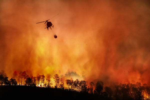
Whiplash Increases Likelihood of Severe Wildfires
Winter began in earnest when an atmospheric river drenched Northern California with record-breaking rainfall totals and dropped a thick blanket of snow on the Sierra-Cascade at the end of November 2024. This historic storm followed another record-breaking weather event in 2024—California’s hottest summer ever recorded. The prolonged months of heat and drought then dried up all of the new growth brought by the rainfall, which created a mass amount of fuel for future wildfire events, including the devastating Eaton and Palisades fires in January, 2025.
Wet conditions encourage the growth of grasses and shrubs, and if a dry period follows, wildfires can flourish. An errant spark and strong winds can light up a mountainside or neighborhood. As KQED reports, the massive wildfires in Southern California followed two years of excessive rainfall, the hottest summer on record, major flooding that re-filled a historic lake in the Central Valley, the most severe drought in recorded history, and so on, all in the last decade.
Breakdown: How Weather Whiplash Fuels Wildfires
- Increased fuel loads: Periods of abundant rainfall, often associated with whiplash events, can lead to a surge in vegetation growth, according to Inside Climate News. When dry and hot conditions return, this dense vegetation becomes a highly flammable “fuel load”.
- Rapid drying: Higher temperatures, a result of climate change, can accelerate the rate at which soil and vegetation lose moisture, exacerbating drought conditions and making the landscape more susceptible to fire, according to KQED.
- Extreme fire conditions: The combination of high temperatures, low humidity, dry fuels, and strong winds can create a “perfect storm” for rapid fire spread and extreme wildfire behavior, as seen in the recent Dragon Bravo Fire in the Grand Canyon, according to Rolling Out.
The recent fires at the Grand Canyon, like the Dragon Bravo and White Sage Fires, demonstrate this pattern. Initially, the Dragon Bravo Fire was being managed, but a dramatic shift to strong winds and dry conditions caused it to expand rapidly and intensely, destroying structures and forcing evacuations.
Expect More Events Like This in the Future
In short, the increasing swings between wet and dry extremes, driven by weather whiplash and climate change, are making wildfires more frequent and severe in areas like the Grand Canyon. “I see the last decade as a preview of what we should expect to see more of,” said Swain. Except that “the wettest wets and the driest dries we’ve seen recently are not the wettest wets and the driest dries we will see in the coming decades.”
—
Photo Credit: Toa55 / Shutterstock.com
