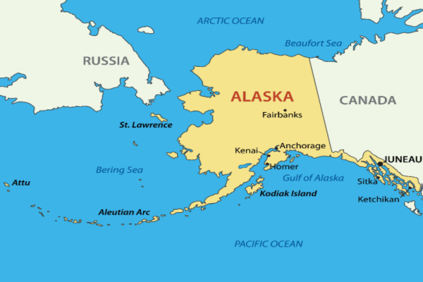
Multiple towns across western Alaska were evacuated as former Typhoon Merbok, which transitioned from a tropical cyclone to an intense, non-tropical wind and rainstorm and became one of the strongest storms to hit the state in recent history.
A surge of water from the Bering Sea hit land on Friday, September 16, covering half of an old airport runway in Golovin, Alaska, located along the west-central coast of the state. The major flooding continued in the city into early Saturday morning, with photos posted by the National Weather Service (NWS) office in Fairbanks showing the community submerged in water.
The flooding and storm surge was so powerful that homes were swept away from their foundations, with one house in Nome, Alaska, floating down the Snake River before slamming into a bridge, according to The Associated Press (AP).
“We’ve had flooding in the past a few times, but it was never this severe,” Clarabelle Lewis, the facility manager for the tribal government and a resident of Golvin for 20 years, told the AP. “We’ve never had homes moved from their foundations.”
On Saturday morning, Alaska Governor Mike Dunleavy declared a disaster for communities impacted by the storm, although Twitter responses were not impressed. “Too little too late,” wrote one. “Or, you know, he could declare ahead of tie based on predictions,” replied another. As of Saturday morning, SEOC reported no injuries as a result of the storm.
Reports from the city of Golovin indicated significant flooding and damage that potentially included old fuel tanks. Golovin Airport recorded both its peak sustained winds and gusts quickly as Friday became Saturday. Peak wind gusts of 63 miles per hour were reported just after midnight and peak sustained winds of 51 mph were recorded at 1 a.m. local time. Shortly after 6:05 a.m. local time, the weather station at Golovin Airport went offline amid the major weather impacts.
Kipnuk, Alaska, located on the southern part of the Alaskan west coast, reported winds of 45 mph with gusts as high as 80 mph, according to an NWS report. The second-highest wind gust of the day was recorded at the Tin City Airways Facilities Sector in Shishmaref, Alaska, when a 67 mph gust occurred at 8:49 a.m. Shishmaref is one of the westmost cities on the North American mainland and only about 35 miles east of Big Diomede Island, Russia.
Ted Stevens Anchorage Airport had multiple cancellations to areas in the state impacted by the storm. Two flights from Anchorage to Ralph Wien Memorial Airport in Kotzbue were canceled on Saturday. A flight to Bethel and Nome was also canceled, according to Flight Aware.
Airports on the western coast of Alaska experienced flooding as the hurricane-force storm brought several impacts to the state. Cameras at Kotlik Airport showed high water and flooding around the area early Saturday morning, including some buildings partially submerged in water. At Nome Airport, vehicles were flooded as the city suffered an eight-foot storm surge.
There have been several reports of damage across Alaska, including a report of at least three homes being moved from their foundations in Hooper Bay, according to Tribal Chief Edgar Tall. Flood waters forced about 110 people to shelter at the Hooper Bay School.
“Western Alaska is facing one of the worst storms in recent history. My team and I are in consistent communication with local, state, and federal officials and stand ready to do what I can at the federal level to support all those who are being impacted,” Alaska Senator Lisa Murkowski said in a Twitter post.
The entire community of Newtok was inundated with water and cut off from the airport. An estimated 100 feet of shoreline was lost in Newtok and at least a dozen homes flooded, according to KTUU.
The National Oceanic and Atmospheric Administration (NOAA) said the cyclone, which had dipped to a pressure of 28.05 inches of mercury (950 millibars) early Saturday morning, was the deepest low pressure in the Bering Sea in September since 2005.
—
Photo Credit: olenadesign / Shutterstock.com
