A storm currently spinning just off the Southeast coast is an example of what meteorologists call a “homegrown” storm. The storm had been thought to become Tropical Storm Helene, but never got organized enough to officially qualify as a named storm.
Regardless, these tropical storms and hurricanes are the ones that can quickly form close to U.S. coasts, in contrast to the ones that slowly march across the Atlantic over a period of days or even weeks. And surprisingly, the U.S. storm threat is usually from these so-called homegrown storms, said Weather.com meteorologist Jonathan Erdman.
In fact, of the 55 hurricanes that impacted the U.S. from 1995 through 2023, only 10 of them first became hurricanes out in the Atlantic between the Lesser Antilles and Africa, he said. “The large majority of them first became hurricanes in the Caribbean Sea, Gulf of Mexico or near the Southeast coast,” he noted in an online forecast post.
What is a “Homegrown” Storm?
According to AccuWeather, a “homegrown” or “homebrew” storm is one that forms close to the coast of the U.S. and is most common during the early part of the hurricane season. (The official Atlantic hurricane season spans June 1 through Nov. 30.)
Homegrown hurricanes are more of a threat than longer-lived hurricanes from far in the eastern Atlantic Ocean, Weather.com reports, simply because they either form or intensify closer to the U.S. “They do that because the Caribbean Sea and southern Gulf of Mexico usually have the most ample supply of warm, deep water. If there are no other negative factors, warmer water leads to a stronger hurricane,” Erdman said.
Will this current Homegrown System become Helene?
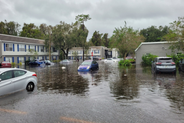
As of 5 p.m. ET on Monday, the center of the storm was located about 45 miles west of Cape Fear, North Carolina. According to the hurricane center, strong winds and heavy rains continue spreading over portions of southeastern North Carolina as the storm moves inland.
However, this particular system is no longer predicted to become Tropical Storm Helene, as of the 5 p.m. EDT update. While this storm has had steady wind speeds of 50 mph, it did not have a closed center of circulation, which is necessary for it to be a named storm. In addition, meteorologists found a frontal boundary in the storm, which tropical cyclones don’t have.
“Based on radar data and surface observations, the poorly-defined low center is likely near the coast or just inland over northeastern South Carolina,” the hurricane center said. “Although it failed to develop a well-defined center and the necessary organization to become a tropical cyclone, the low has produced significant impacts today, with life-threatening flash flooding reported in portions of southeastern North Carolina and wind gusts in excess of 60 mph along the coast.”
What’s Next after this “Not” Helene?
If this storm does not become Helene, the good news is there are no other tropical systems in either the Atlantic or Pacific Basins other than Tropical Depression Gordon, currently spinning harmlessly out to sea far from land. The system that will become Tropical Storm Helene is not on the board yet. Storm names after Helene include Isaac, Joyce and Kirk.
—
Photo Credit: america365 / Shutterstock.com
